
Date: 27th January 2017
Company: Myself and Alan
Distance: 21km, Ascent: 1300m
Time: 7Hrs 15Mins
On Thursday morning, I contacted Mountaineering Scotland, formerly the Mountaineering Council of Scotland, to obtain the padlock combination to gain access to Glen Strathfarrar. After providing my full name, membership number, car registration, telephone number, number of passengers and details of my intended hills, I was provided with the four digit code. In winter, vehicular access to the glen in is now restricted to Mountaineering Scotland members only.
I have visited Glen Strathfarrar numerous times previously and mostly in winter. It is a lovely glen with literally dozens of deer roaming around the roadside. If you are lucky, you may also spot some feral goats. Winter is my favourite time of year to visit this glen as in winter you can avoid contact with the gatekeeper. I suspect the private road leading to Monar Dam was built using public money to allow for construction of the Monar Dam. I also wonder if SSE pays for, or at least subidises, road maintenance. I really don't like the fact access to this glen is restricted. If the road was indeed constructed using public money then it should be open for the public to use and not restricted by the estate.
On Friday morning, I set off from home at 05:00 picking-up my friend Alan en-route. We arrived at the gate a few minutes before 08:00 and once through the gate drove to and across the Monar Dam and then a few kilometres beyond to the parking area at the Gleann Innis an Loichel Power Station.
Once suited and booted we set off for An Cruachan. An Cruachan is said to be one of the remotest hills in Scotland. That is certainly the case if approaching An Cruachan from Kintail-side with an overall distance to cover in excess of 40km. However, if approaching from Strathfarrar side, the walk is only a little over 20km.
Click here to see a map of the route undertaken
The flow of water eminating from the power station was impressive.
Gleann Innis an Loichel Power Station:

The temperature en-route to our starting point ranged between -2C and -5C. It was a cold morning and ice on the track was plentiful. I am not sure if this slowed us down at all but it certainly stopped us from being able to walk in a continuous straight line. Despite setting off around sunrise, we didn't witness the sun coming up. The colour of the sky to the east was however still nice.
Looking back to Gleann Innis an Loichel Power Station:

Circa 1km beyond the Gleann Innis an Loichel Power Station, I stopped briefly to take some photos and then crossed two small footbridges.
Hydro scheme:

It was great to walk and catch-up with my friend Alan. It is almost a full year since I last attended a Moray Mountaineering Club meet, something I need to rectify in 2017.
Looking back towards Glen Strathfarrar:

As we progressed along the icy track, we passed the remains of what was possibly once a small house.
Ruin next to track:

On reaching a track junction, which is not marked on the map, we took the right fork. Despite the right fork being the wider path it turned out we should have taken the left fork. On realising our error, we cut back towards the correct path via an expanse of peat hags. There would be much more of this type of terrain to come.
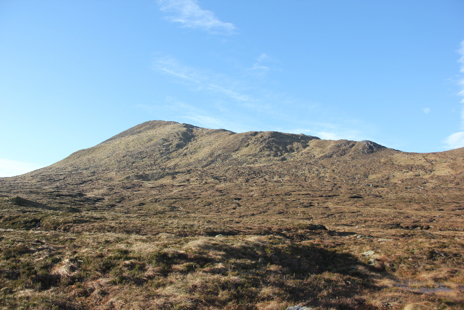
As we progressed through the glen we could see the Mullardoch Munros towering above. On gaining a bit more height and approaching the col, we got our first views of An Socach, Aonach Bhuidhe and our intended hill, An Cruachan.
An Socach, Aonach Bhuidhe and An Cruachan coming into view:

An Cruachan looked much closer than expected. It turns out looks can however be deceiving! Despite its proximity, the terrain between the col and the base of An Cruachan is awful. We were at least fortunate that much of the ground was frozen.
An Cruachan:

A short distance beyond the col, we stopped for our first break of the day. Instead of following the route detailed within the SMC Fionas and Donalds book, we opted to take a more direct approach aiming for the base of Beinn Bheag.
I really enjoyed seeing a number of Munros that I have not visited in some time.
Looking across Loch Monar towards Bidean an Eoin Deirg and Maoile Lunndaidh:

An Cruachan:

To get to the base of An Cruachan we had to cross three burns. None of the burn crossings were difficult but we did have to take care due to ice on the rocks.
Crossing the Allt Fuaran Riabhachain:

An Cruachan across the Allt Riabhachain:

On reaching the base of Beinn Bheag, we met the final couple of hundred metres of path leading up from Pait Lodge. We followed this path to its end and then commenced our ascent of An Cruachan.
Initially it had been our intention to ascend Beinn Bheag and then work our way along the ridge to An Cruachan. Instead we opted for a rising traverse skirting just below the rocky 572m top.
Traversing up past the 572m top:

An Cruachan:

The views from the ridge of An Cruachan were pretty-good. I especially liked the view across to Beinn Dronaig and Lurg Mhor (Meall Mor). Seeing Lurg Mhor close-by made the remoteness of An Cruachan hit home.
Great views across to Beinn Dronaig and Lurg Mhor (Meall Mor):

Looking back to 572m top and beyond:

The ascent from the col to the summit of An Cruachan was very pleasant compared with the expanse of peat hags recently crossed.
Alan:

Lurg Mhor (Meall Mor) and Loch an Tachdaidh:

An Riabhachhain and An Socach:

We reached the summit of An Cruachan approximately 3Hrs 45Mins after setting off. Had we followed the SMC guidebook route, we suspected it would have taken us less time. We therefore decided to return via the suggested route.
Approaching the summit of An Cruachan:

We spent around 10-15 minutes at the summit taking photos, admiring the views and having a bite to eat and drink. For such a remote hill, An Cruachan does have a very large well-built cairn.
Alan atop An Cruachan:

Myself atop An Cruachan:

Looking across to Aonach Bhuidhe:

Large summit cairn:

From the summit of An Cruachan, we made our descent back to the col and then followed a nice grassy line off the hill heading down to the expanse of peat hags.
Looking back to An Cruachan:

Crossing several kilometres of peat hags was certainly not pleasant.
Crossing several kilometres of peat hags:

An Cruachan:
On the map, this area is called Pait Forest. While there are no trees here now, there are countless remains of old tree roots which are possibly hundreds of years old.
Pait forest old tree roots:

It was a relief to eventually reach the col but another kilometre of rough terrain still lay ahead before reaching the start of the path as marked on the map.
View towards Loch Monar:

An Cruachan:

Once back on the path and then track, we made fairly fast progress back to the car.
If you want a 40km+ walk, on mostly excellent tracks and paths, do this hill from the west. If you want to halve the distance by approaching from the east, bear in mind you will need to cross several kilometres of peat hags there and back and also ascend 1300m for what is a 705m Fiona.
Thanks to Alan for accompanying me on this walk. Twelve Fionas now remaining.